
Charles Booths London Poverty Maps 45869
Charles Booth’s landmark survey of 19th-century London, published for the first time in one volume.
Charles Booth’s landmark survey of life in late-19th-century London, published for the first time in one volume.
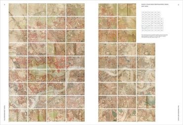
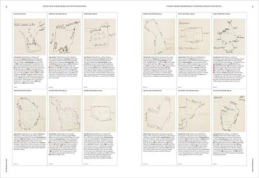
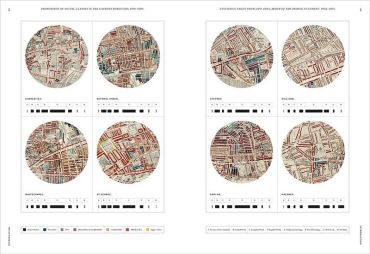
In the late 19th century, Charles Booth’s landmark social and economic survey found that 35% of Londoners were living in abject poverty. Between 1886 and 1903, Booth’s team of social investigators interviewed Londoners from all walks of life, recording their comments, together with their own unrestrained remarks and statistical information, in 450 notebooks. Their findings formed the basis of Booth’s colour-coded social mapping (from vicious and semi-criminal to wealthy) and his Inquiry into the Life and Labour of the People of London. Organized into 12 geographical sections, Charles Booth’s London Poverty Maps presents the meticulously hand-coloured preparatory and final printed social mapping of London. Accompanying the colour-coded maps are selected reproductions of pages from the original notebooks, containing anecdotes related by Londoners of every trade, class, creed and nationality together with observations by Booth’s interviewers that reveal much about their social class and moral views. An introduction by Mary S. Morgan clarifies the aims and methodology of Booth’s survey, and six themed essays by experts in the field contextualize the survey’s findings, illustrated by evocative period photographs.Completing the re-evaluation of Booth’s seminal social survey are newly rendered infographics presenting the raw statistics relating to living conditions,employment status and poverty levels for each geographical section of London.
Charles Booth’s landmark survey of life in late-19th-century London, published for the first time in one volume.
In the late 19th century, Charles Booth’s landmark social and economic survey found that 35% of Londoners were living in abject poverty. Between 1886 and 1903, Booth’s team of social investigators interviewed Londoners from all walks of life, recording their comments, together with their own unrestrained remarks and statistical information, in 450 notebooks. Their findings formed the basis of Booth’s colour-coded social mapping (from vicious and semi-criminal to wealthy) and his Inquiry into the Life and Labour of the People of London. Organized into 12 geographical sections, Charles Booth’s London Poverty Maps presents the meticulously hand-coloured preparatory and final printed social mapping of London. Accompanying the colour-coded maps are selected reproductions of pages from the original notebooks, containing anecdotes related by Londoners of every trade, class, creed and nationality together with observations by Booth’s interviewers that reveal much about their social class and moral views. An introduction by Mary S. Morgan clarifies the aims and methodology of Booth’s survey, and six themed essays by experts in the field contextualize the survey’s findings, illustrated by evocative period photographs.Completing the re-evaluation of Booth’s seminal social survey are newly rendered infographics presenting the raw statistics relating to living conditions,employment status and poverty levels for each geographical section of London.
Епохальне дослідження Чарльза Бута про Лондон 19-го століття, вперше опубліковане в одному томі.
Епохальне дослідження Чарльза Бута про життя в Лондоні кінця 19-го століття, вперше опубліковане в одному томі.
Наприкінці 19-го століття знакове соціально-економічне дослідження Чарльза Бута виявило, що 35% лондонців жили в крайній бідності. Між 1886 і 1903 роками команда соціальних дослідників Бута опитувала лондонців з усіх прошарків суспільства, записуючи їхні коментарі разом із власними нестриманими зауваженнями та статистичною інформацією у 450 блокнотах. Їхні висновки лягли в основу кольорової соціальної мапи Бута (від порочних і напівзлочинних до заможних) та його «Дослідження життя і праці лондонців». Об'єднані у 12 географічних розділів, «Карти бідності Лондона» Чарльза Бута представляють ретельно розфарбовані вручну підготовчі та остаточні друковані соціальні мапи Лондона. Кольорові карти супроводжуються вибраними репродукціями сторінок з оригінальних записників, що містять анекдоти, розказані лондонцями всіх професій, класів, віросповідань і національностей, а також спостереженнями інтерв'юерів Бута, які розкривають багато цікавого про їхній соціальний клас і моральні погляди. Вступ Мері С. Морган пояснює цілі та методологію дослідження Бута, а шість тематичних есе експертів у цій галузі контекстуалізують результати дослідження, проілюстровані ретроспективними фотографіями. Завершує переосмислення фундаментального соціального дослідження Бута нова інфографіка, яка представляє первинну статистику щодо умов життя, статусу зайнятості та рівня бідності для кожної географічної частини Лондона.
- АвторMary S. Morgan
- КатегоріяСоціологія
- МоваАнглійська
- Рік2019
- Сторінок288
- Формат270х370 мм
- ОбкладинкаТверда
- Тип паперуКрейдований
- ІлюстраціїКольоровіКарти
- ЖанрСоціологіяАтласи, карти
- Вік16+
2782 ₴
Відділення Нова Пошта80 ₴
Поштомат Нова Пошта80 ₴
Кур’єр Нова Пошта120 ₴
Відділення УкрПошта50 ₴
Кур’єр за адресою90 ₴


допоможіть тим, хто ще не читав